Several dozen plantations and farms were established south of the St. Johns River on the east and west shores of Pablo River, part of the Intracoastal Waterway today, linking the St. Johns River and the North River to St. Augustine. One of the earliest indigo planters, Thomas Morris, had successful farms of 200, 400, and 500 acres east and west of Pablo River, all close to the St. Johns River. In the 1780s, after Morris’s death, these tracts were acquired by Robert Ballie and cultivated until the end of the British era. Ballie also bought tracts south of the St. Johns River near Pablo and Evans Creek from Thomas Harris, executor for the estate of Robert Harris.

Map for Thomas Morris

Plat map of tract awarded to Thomas Morris
Richard Sill, an overseer for both governors of East Florida, James Grant and Patrick Tonyn, acquired several small farms on Pablo River, including two granted to Andrew Nowland in 1765 that were cultivated continuously for nineteen years, first by Nowland and then by Sill. Sill profited from his years as an overseer by acquiring forty-two slaves to cultivate his own tracts and to erect numerous buildings. The slaves and as many buildings as they could disassemble and pack aboard transports were all evacuated to Kingston, Jamaica.
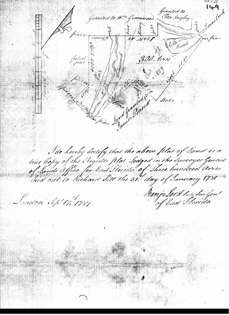
Plat map of 300-acre tract on Evans Creek and Pablo River purchased by Richard Sill
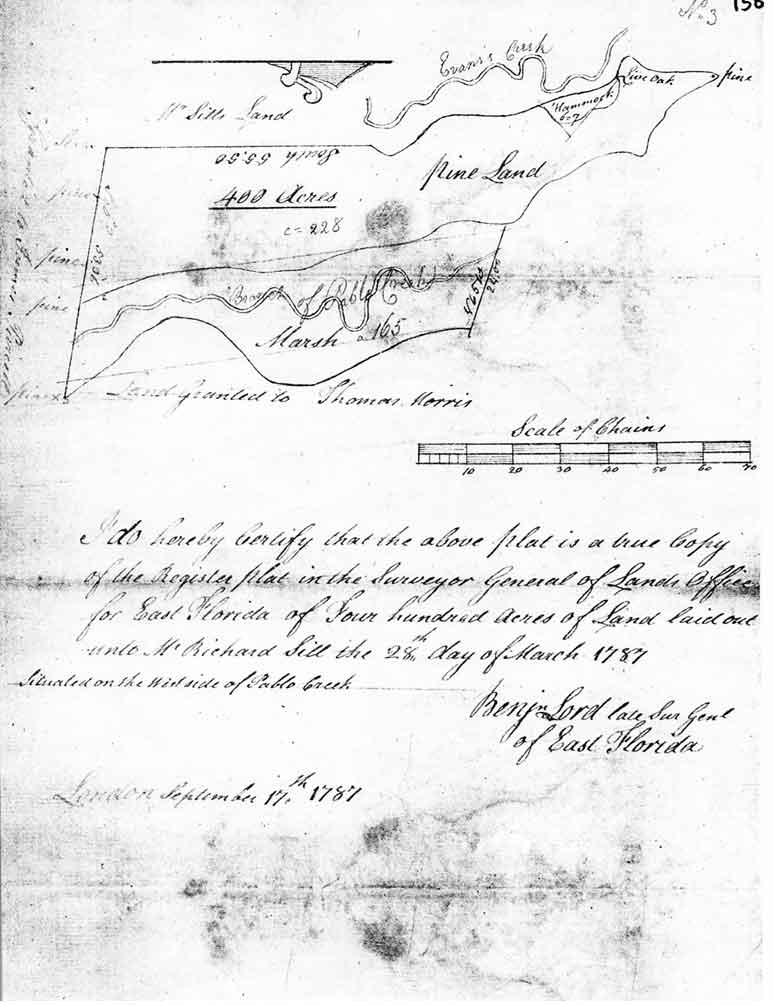
Plat map of a 400-acre tract on Evans Creek and Pablo River acquired by Richard Sill
Frederick Robertson, a plantation manager for Richard Oswald and James Moncrief, and a planter in his own right, acquired 500 acres east of Pablo River. After the evacuation of Savannah and Charleston, several refugee families settled on Robertson’s land and paid him a percentage of their annual produce. Robertson, however, continued to cultivate his own 1,300 acres at the head of Indian River.
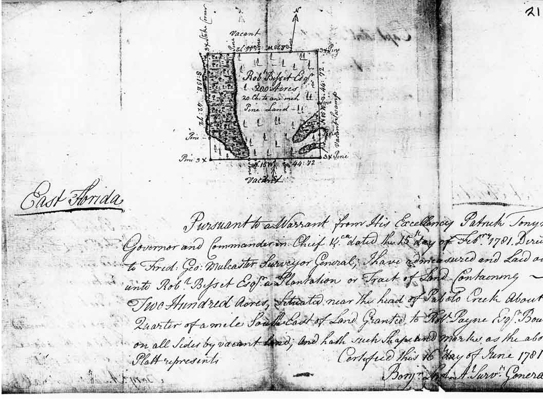
After raids by Spanish forces destroyed several plantations south of Tomoka River, Alexander Bisset and Captain Robert Bisset moved their operations to Pablo River and North River, where estates south and east of the St. Johns were generally secure throughout the war. Captain Robert Bisset planted continuously in East Florida for seventeen years, from 1767 to 1784, when he transported his slaves and other movable property to the West Indies. In all, he acquired 9,500 acres in nine tracts and made five different settlements. His fenced and cultivated land exceeded five hundred acres. Bisset believed that the eighty-one slaves he owned, even “at the most moderate estimate should have brought him a clear income of £1000 a year.” His son Alexander owned an additional thirty-five slaves. After Spanish raiders plundered and destroyed his plantations along Halifax River and stole eighteen of the slaves, Bisset moved the remaining ninety-eight laborers to a settlement called Caledonia on Pablo River near the St. Johns. On this tract his slaves erected good frame dwellings, barns, storage sheds, and other plantation structures, and concentrated on naval stores production. The Bissett slaves worked at four tracts along the Pablo and North Rivers.
George Millar, a refugee from Georgia, settled in 1779 on 900 acres west of Pablo River just two miles south of the St. Johns. Millar estimated that St. Johns Town was just two miles away from his property by land. Evans Creek ran through the three tracts he purchased from executors of Alexander Gray’s estate and combined into one naval stores and provisions plantation. The land had not been cultivated when Millar purchased it, but within one year his forty-three slaves cleared, fenced, and planted seventy acres in corn and peas, and slashed and boxed 25,000 pine trees to catch the sap for turpentine. These same workers also erected a dwelling house for Millar, measuring thirty-two by twenty-eight feet, along with a kitchen, barn, stable, slave quarters, and other outhouses. When the British settlers departed East Florida in 1784, Millar was forced to leave behind thirteen horses, carts, wagons, hogs, canoes, tools, household furniture, crops in the ground, twenty-five barrels of turpentine valued at twenty-five shillings each, a tar kiln, and lumber the workers were using to make barrels to hold turpentine.

Peter Berwick , born in England, but subsequently a migrant to Georgia and South Carolina, was evacuated from Charleston in 1782. He acquired land near the mouth of the St. Johns River where he built a small house and cleared enough land to raise subsistence corn and potatoes. He also grazed two horses and two cows. His twenty-five hogs were abandoned with the horses and cows when he migrated to Nova Scotia in 1784.
Somewhere near the mouth of the St. Johns River, Archibald Brandon, a South Carolina Loyalist, acquired 250 acres of land and built a frame house and a log cabin, along with out buildings. Brandon cleared and planted five acres of provisions before he migrated to Nova Scotia leaving behind an eighteen foot keel boat.
William Brockie , a Scot, settled in South Carolina but was evacuated to East Florida in 1782. Brockie acquired a 300-acre tract on the Diego Plains south of Brandon, where three male and two female slaves built a dwelling house, barn, kitchen and other buildings, cleared and fenced twenty-five acres of land, and tended livestock. At the end of the British occupation, all five slaves escaped from Brockie. He was also forced to leave eight horses and seven cows behind when he departed the province.
William Russell came to St. Johns Town following the evacuation of Charleston, accompanied by nine slaves. He became a vendue master and factor in the sale of lumber, kept a retail store, and bore arms for the Crown. On a nearby rented parcel Russell’s nine slaves cultivated provisions and cut lumber. When he left for Dominica in 1784, Russell was forced to leave behind his house, livestock, and two young and valuable slaves, a cooper named Tom and a carpenter named Isaac “who were seduced…from his service on account of his coming to the West Indies.” Two large rafts of lumber, each loaded with about 3000 feet of lumber, were swept away by the tide before he could arrange a sale.
A 500-acre tract in this vicinity was granted in February 1781 to Peter Edwards, a Loyalist refugee from South Carolina. The land was located at a cedar swamp near a tract granted to William Johnson, approximately forty miles north of St. Augustine, near today’s Theodore Roosevelt Preserve, on a parcel known as Cedar Swamp. Edwards owned other properties in East Florida on the St. Marys River and at Twelve Mile Swamp northwest of St. Augustine. He brought sixty slaves into the province.
A map preserved in the Public Office (MR 2/6, “Exact Plan of the River St. Johns in East Florida”), attributes a 10,000-acre grant to Edward Wood at the western shore of Pablo River and St. Johns River, and a settlement listed as the property of “Hassard” which adjoins Wood’s tract upriver at the juncture of Mt. Pleasant Creek. The mapmaker, perhaps Joseph Purcell, was in error with both attributions: Richard Hazzard farmed an indigo plantation at Fort George Island on the north of St. Johns River, and Edward Wood was granted a 10,000-acre tract further upriver, near the Cowford, at Little Pottsburgh Creek.

Bibliographic Information
Surveys of Morris’s tracts are in T77/23/fragments. Turnbull and Moultrie to James Grant are in the James Grant Papers and in Daniel L. Schafer, Governor James Grant’s Villa: A British East Florida Indigo Plantation (St. Augustine Historical Society, 2001. T77/2/12-Bissett; T77/11/12- Miller; T77/19/2-Sinclair; T77/15/10-Robertson; T77/2/10-Berwick’ T77/2/16- Brandon ; T77/2/18-Brockie; T77/15/24-Russell; T77/5/3-Edwards.