(RE-)MARKING THE UNMARKED:
GROUND-PENETRATING RADAR AT RED HILL CEMETERY
In June, 2022, the Red Hill Cemetery Project used ground-penetrating radar equipment and mapped the cemetery, including existing indicators of burial locations, and identifying unmarked graves.
Historic African American burial grounds may often appear neglected and sparsely utilized due to differences in maintenance and stone marker usage patterns as compared with other cemeteries. These differences in funerary landscapes often make these important spaces and their associated monuments targets for vandalism and more systemic mistreatment, be it intentional or otherwise. At Red Hill Cemetery, the physical, surface evidence for graves in the form of burial markers is but a small percentage of the many hundreds of burials indicated in historic records. Vandalism and mistreatment of the site, along with natural vegetation growth, has further obscured the boundaries and importance of this location for past and current community members for whom the site continues to carry great meaning. Evidence of graveside visitation and active engagement by contemporary descendants indicate that the site is still a living landscape. Using ground-penetrating radar (GPR), we attempt to (re-)mark unmarked grave locations in a small portion of the cemetery. Evidence of graves in areas with limited indications of burials helps to further highlight and delineate the actual boundaries of the cemetery property essential for ongoing preservation efforts.
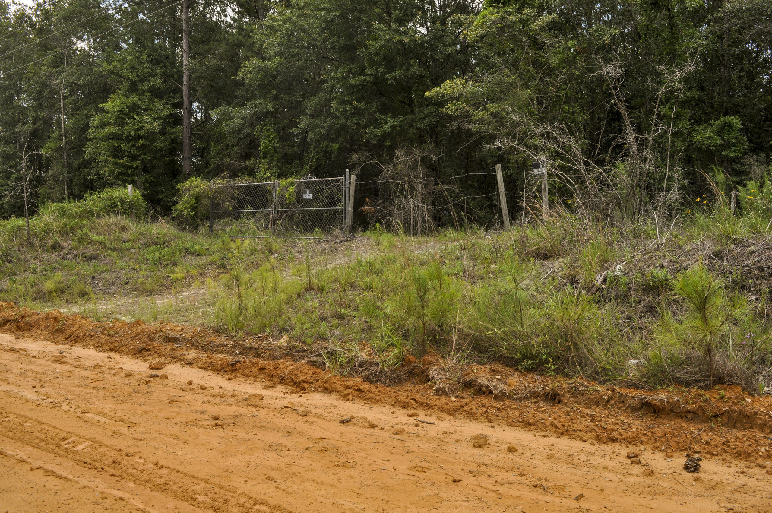
Approaching the approximately six-acre Red Hill Cemetery, the only indicator of the site is a small remnant fence that outlines the northwest edge of the community’s oldest African American cemetery. Beyond the fence, trees and dense brush dominate the landscape, obscuring the original pathways through familial burial plots. Gravestones, scattered bricks, and broken concrete vaults underline and punctuate the sacrality of the space, representing a few of the hundreds of graves that no doubt remain unidentified. The anthropology research portion of the Red Hill Cemetery Project assisted in mapping the cemetery, including existing indicators of burial locations, and identifying unmarked graves. By mapping and recording the cemetery’s current condition, gathering oral histories in the local community, archiving historical documents, and building a database of names and dates of individuals interred here, we seek to preserve and memorialize the lives of these important members of the Waycross community.

CHALLENGES OF MAPPING AND GPR AT RED HILL CEMETERY
Initially, we hoped to map and document current conditions, and conduct GPR scans to analyze sections of the cemetery to locate unmarked graves. However, due to the cemetery’s current conditions, mapping and GPR survey efforts have proven to be challenging. The main sections of the property are covered by the trees, thick brush, and tree roots, which do not allow for the clear passageways and open spaces necessary for successful GPR scans to be conducted. Moreover, tree and brush coverage also make the use of traditional archaeological mapping tools — that is, modern surveyors’ transits — exceedingly difficult to use. Intervening vegetation requires the transit base station and associated datum benchmarks to be moved repeatedly; an operation that can take as much as 60-90 minutes per move. While mapping the cemetery in this environment is possible, the multiple datum and transit moves would require an inordinate amount of time and effort. Moreover, the multiple moves and datums would also introduce complexity and errors in the resulting map. Attempts at locating gravestones using thermal scans, GoPro 360⁰ scans, and infrared photography are underway and may yet prove successful. In the meantime, the Red Hill Cemetery Project has focused on one portion of the cemetery more amenable to traditional archaeological mapping techniques and GPR survey.


THE FRONTAGE PORTION OF RED HILL CEMETERY
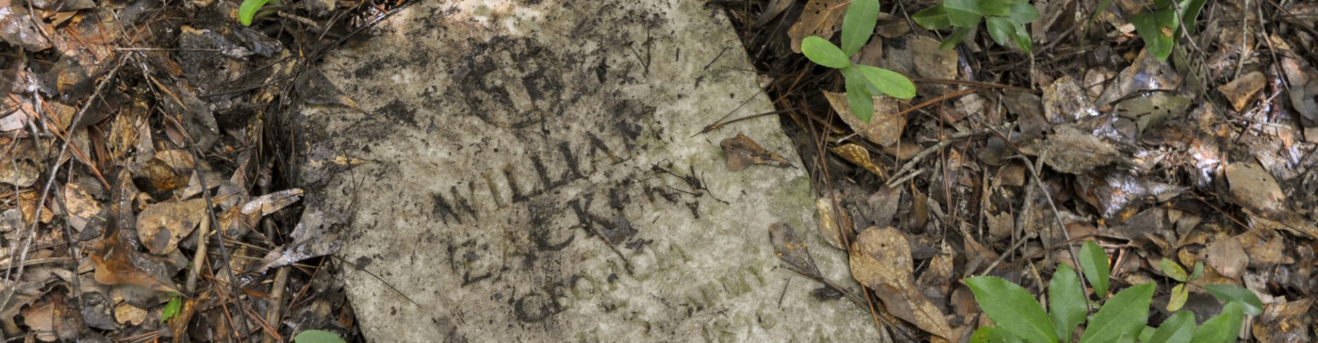
From the clay road to the entrance of the cemetery there is a slight incline of about one meter. Before reaching the wooded area of the cemetery, there is a clear stretch of land that runs directionally northeast to southwest. This section is cleared and maintained for the telephone poles and power lines that bound the northwest side of cemetery. In this section of cleared ground, there are six marked graves of a type typically referred to as ledgers, full stone or concrete slabs that cover the extent of the grave and are flush with the ground.


Of these six graves, only one ledger remains fully intact. The remaining five exhibit damage resulting from natural weathering and human activity. Some ledgers include handwritten inscriptions produced while the concrete was wet. One has a rusted temporary metal grave marker that is no longer legible. The existing ledger stones indicate that this cleared area is part of the cemetery and was used for burials in the past. However, without a systematic GPR scan, it is unclear if the existing stones mark the only burials in this portion of the cemetery.

MAPPING THE SURFACE FEATURES
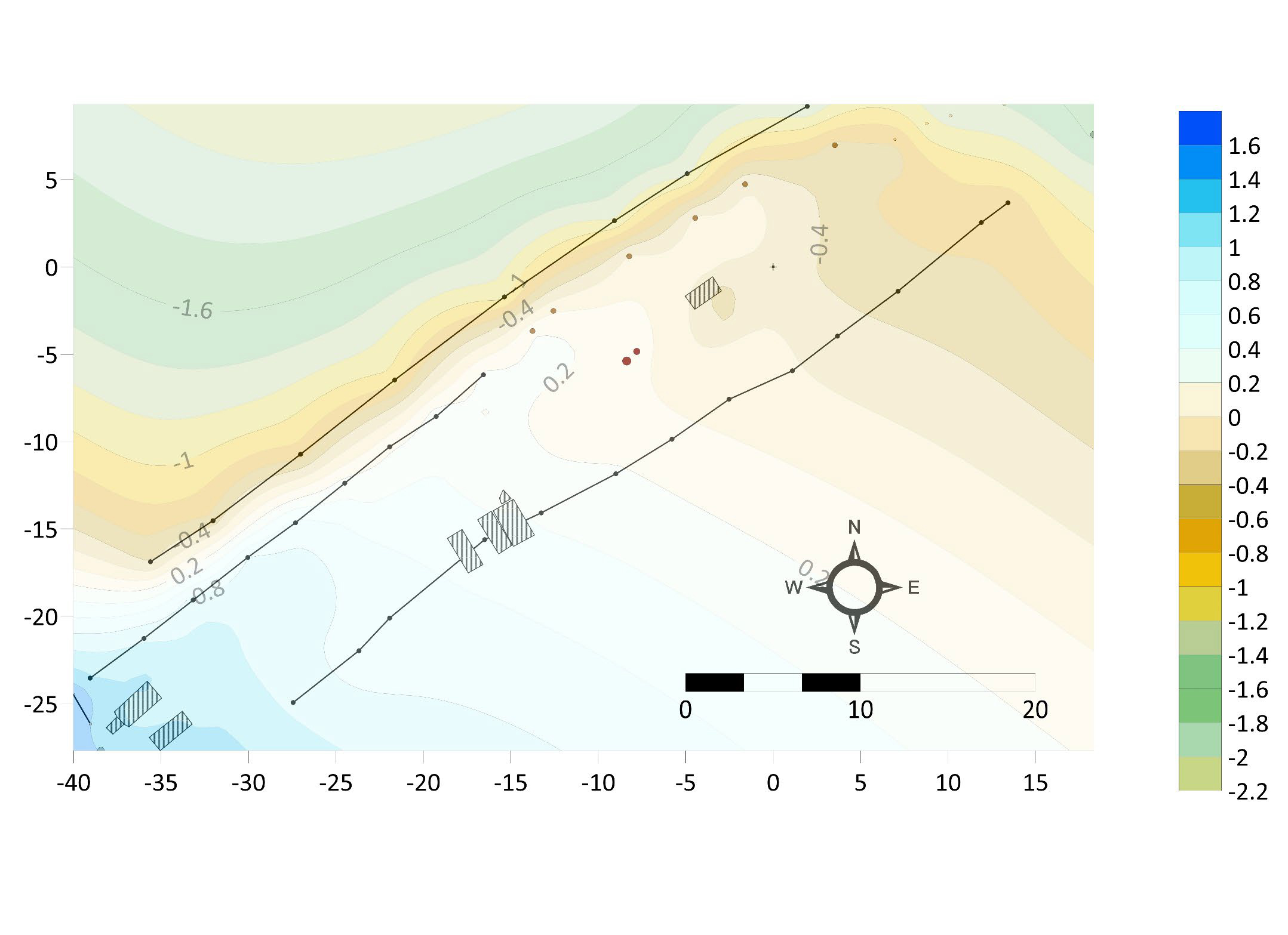
Prior to conducting GPR surveys, it is typical to create as detailed a map of the area in order to provide a reference map of known surface features that can be correlated with sub-surface anomalies identified in the GPR survey results. We began by creating a map of the approximately 15x60 meter cleared frontage area using a Sokkia model SCT6 surveyor transit. The transit, also known as an electronic distance meter, provides an easy method to obtain X, Y, and Z coordinates relative to the position of a datum point. UNF anthropology students used the surveyor transit to capture and map points from the road, remaining fence posts, cleared frontage parameters, existing ledger markers, telephone poles, and topographical depressions and elevations.

All points were collected and recorded in Microsoft Excel, and then exported and processed in the Golden Software Surfer mapping program. This program interpolates the data uploaded into a statistical grid including surface area, a projected planar area, and different volumetric calculations, producing a variety of maps including contour, color relief, and 3D surface maps. These maps allow us to compare existing surface features and topography with the results of our GPR survey. In this version of the map, elevation above or below the datum is represented with colored shading and the existing ledger gravestones are shown as hatched rectangles.
GPR SURVEY
Ground-penetrating radar is a geophysical, remote sensing technique that involves sending pulses of radar energy into the ground and collecting energy that is reflected back to the instrument. Differences in the amount of reflected energy (or signal amplitude), direction of reflections, and the time since transmission of the radar pulse indicate the presence and depth of changes in soil chemistry and density. GPR is consequently useful for identifying subsurface features of interest. GPR is used by construction firms, utilities corporations, and archaeologists to provide insight into possible subsurface materials prior to, or in place of, costly and potentially damaging excavations. A wide range of studies have demonstrated GPR’s usefulness in locating unmarked graves, particularly in historic cemeteries.


The GPR equipment used for this project is a hand-towed, ground-penetrating radar system from Sensors & Software Inc. of Ontario, Canada. The system includes 500MHz transducers, a control module and power supply, digital video logger, odometer wheel, and associated analytic software. The 500MHz transducers typically provide resolution to maximum depths of 2.5 to 8 meters, depending on local conditions and system settings. The system’s hand-towed configuration and narrow design allow it to be effectively used in relatively flat, cleared terrain.
A 5x50-meter grid was established beginning in the southwestern end near two of the existing ledgers, following along the fence-post line near the road, to the eastern fence line, and the southern end which border the woods. Within this grid, X and Y lines were created at 1-meter intervals allowing for the collection data in a close cross-sectional manner to aid in the further detection of underground anomalies.
The resulting GPR data was processed using Sensors & Software EKKO Project 6 analytical package. The individual survey lines were organized into their grid arrangement with X lines running approximately east-west and Y lines running roughly north-south. GPR survey lines were further processed to improve signal-to-noise ratio. For example, due to the attenuation of radar pulse signals as they pass through soil, most analysts amplify the signals received from greater depth. This amplification is referred to as “gaining” the signal data. Additionally, given the electrical properties of the ground and the proximity of the GPR transmitter and receiver, low frequency noise, referred to as “wow”, is often introduced. A high-pass filter called DEWOWing can be used to remove this noise. Finally, the raw GPR signal data takes the form of a sine wave with both negative and positive amplitude pulses. In some data visualizations (e.g., line profiles) this back-and-forth amplitude is desirable. In other cases (e.g., map slices) it is preferable to have all amplitudes showing in one direction. A data processing technique called “enveloping” can convert GPR signal data from wavelets of both positive and negative amplitudes to a mono pulse form. For line profile views, the data have been DEWOWed and gained. For map slices, the data have been DEWOWed and gained and then envelope processing applied. Finally, the depth estimates of amplitude signals in this data set have been approximated using a radar velocity estimate of 0.10 meters per nanosecond.
RESULTS OF THE SURVEY
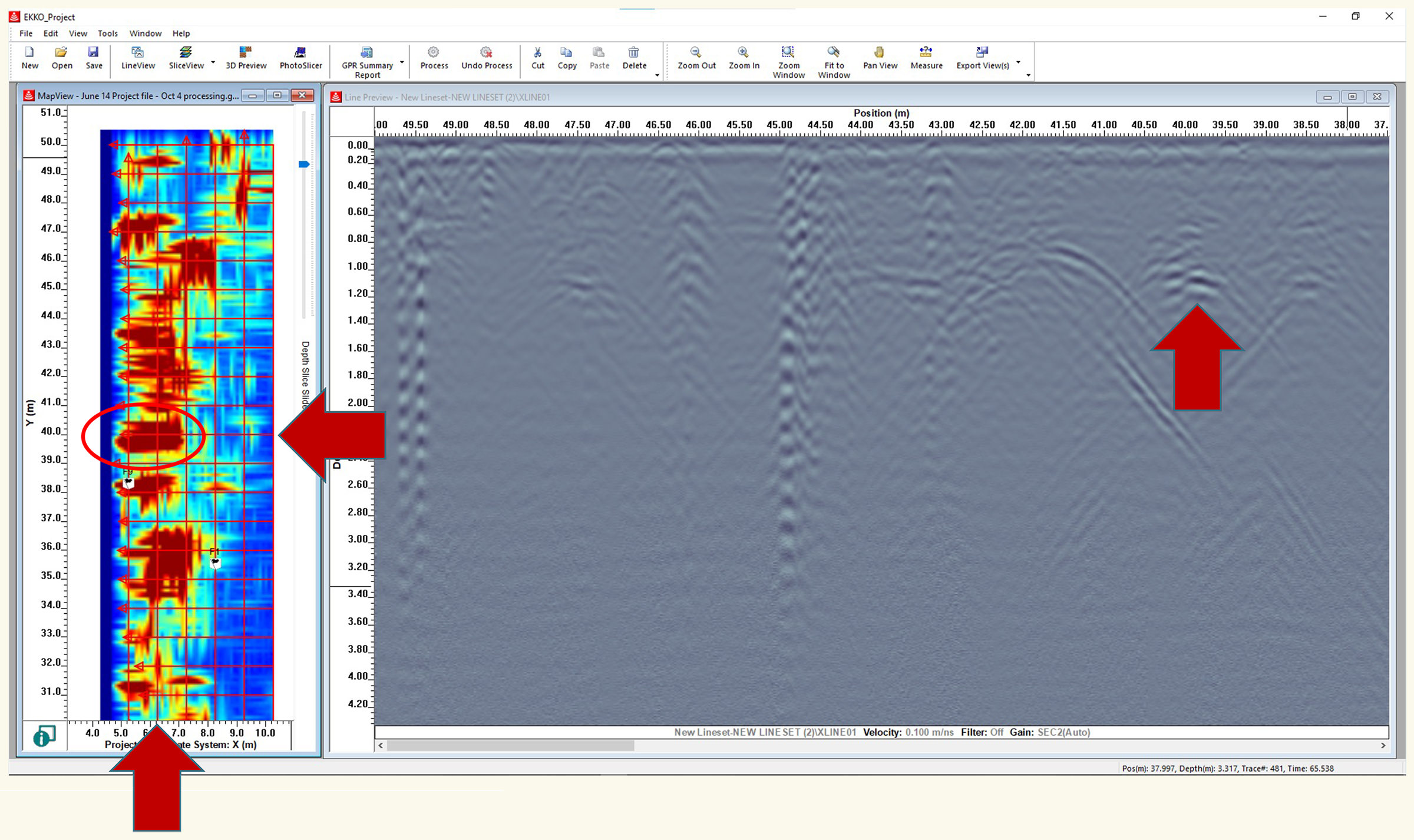
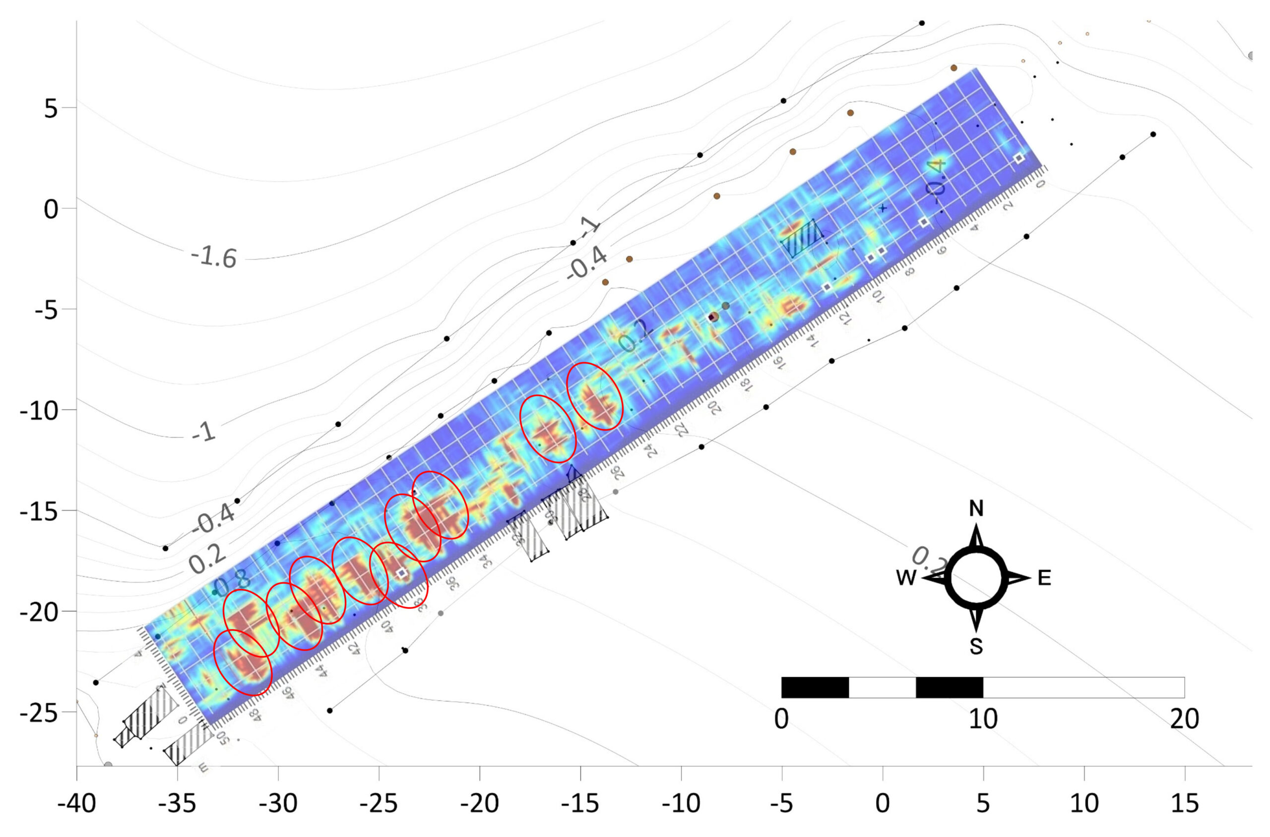
Once the GPR map slices are adjusted and corrected in the software, individual profiles can be examined for anomalies. Here we see a strong hyperbola at approximately 40 meters along the 01 X line, a southwest to northwest survey line that was run approximately 1 meter from the ends of ledger grave markers. In conjunction with signals from parallel and perpendicular survey lines, the combined signals on the map slice appear as a strong rectangular signal imaged in red. Typically, the strength of individual hyperbolas can be affected by factors such as depth of the object, age of the object, the material of the object, differences between the object and surrounding material, and voids.
Another likely indicator of a possible grave is the depth at which a reflected hyperbola appears. While the depth of a grave can vary, marked graves in historic cemeteries most commonly correspond to GPR hyperbolas appearing between 1 to 1½ meters deep, with the average being close to 1 meter. Given time differences and the nature of soil conditions, slight variations in depth per grave are expected. At the 01 X survey line from Red Hill cemetery a series of hyperbolas with apexes around the 1-meter-deep mark are clearly evident. Looking at the associated map slice these high amplitude GPR signals correspond to possible unmarked graves.
After analyzing the GPR data slices, the map slices can be cross-compared to the topographical map created using the mapping transit. The GPR map slice is laid over the previously constructed topographical map. Given the presence of many high amplitude signals at the 1-meter depth visible in the profile views, a map slice from a depth of 1.05 meters was selected. By comparing the maps, the areas of high amplitude reflections can be viewed in relation to the existing features on the survey area.
The patterns of high amplitude reflections in comparison with the map, indicate the possibility of multiple unmarked burials within the frontage portion of the property, especially in the southwestern half of the grid. The correlation between the existing graves and the high amplitude areas further aid in the confirmation of unmarked burials, as many families bury relatives within the same plot or space of a cemetery. The smaller high amplitude reflections that appear to be unmatched with similar strong signals on parallel or perpendicular lines may be a result of tree roots, large rocks, pieces of metal, etc.
IMPLICATIONS AND CONCLUSIONS
In examining the GPR results as a whole, the evidence strongly suggests a minimum of ten additional unmarked graves within the surveyed frontage portion of Red Hill Cemetery. These ten possible graves are characterized by high amplitude GPR signals on multiple parallel and perpendicular survey lines. Additionally, the signals appear in a linear fashion as we would expect for a cemetery. Finally, the rectangular signals we recovered fall in a northwest-southeast alignment that is similar to three of the nearby graves marked by ledger stones.
The preliminary GPR survey has identified a series of possible unmarked graves on the northwest edge of the current boundary of the Red Hill cemetery. These results have important implications for future preservation and care for the property. Mowing and maintenance on the site, intended to provide access to utilities lines, can damage the existing markers and unmarked graves and contribute to the threats from erosion. It is important to note that the current entrance that is used to access the property, has focused attention on this modern-day frontage portion of Red Hill Cemetery. However, GPR surveys of other portions of the cemetery edge might help (re-)mark the boundaries of the cemetery and identify additional unmarked graves.
Contributors: Kelly Melendez, Alex Diaz, Magdalynne Alley, Dr. Gordon Rakita